Saturday, 1 August 2026 at 5:00 pm to Sunday, 2 August 2026 at 5:00 pm
Organiser: Zade Viggers
You've visited the Ōrongorongo river & the associated valley, but have you ever met the maunga itself?
Located in the much less frequented* northern half of the Remutaka Range is a hill after which our popular day walk valley is named**. I propose we go and camp on it in flys so we can feel some solidarity for the poor folk freezing their toes off on Snowcraft the same weekend.
The walk in will involve some degree of bush bashing, though we have a tradeoff available between extra bushbashing v.s. some more road walking. We'll also try and do all the navigation with just our trusty topo maps and compasses!
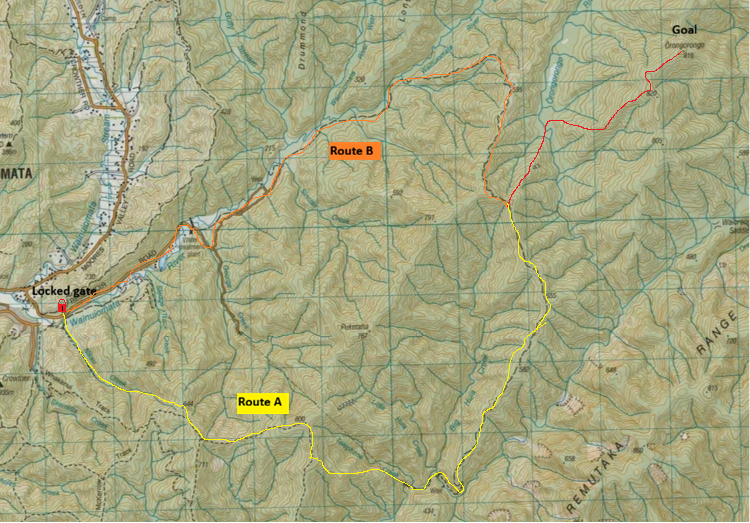
As you can see in the above low-resolution image, the good folk at the Regional Council have decided that it's in out best interests to lock a gate in the middle of a road which would save us a lot of time if we could drive along. Not to worry however, as we have two (2) alternative routes available.
For route A we walk from what appears to be a carpark ^1 on the ariel imagery along the concepts of a track and then bush bash up a stream until we join another track ^2. We follow the track for a little whiile before cutting down Telephone Creek ^3 to where a tunnel*** comes out ^4. We then walk along the dirt road unil we get to the spur that we will cut down toward Ōrongorongo ^5 (this is the same place route B turns off the road).
At the bottom of the spur we cross the river**** and head up another supr ^6 towards high point 820 before continuing across the saddle to Ōrongorongo maunga itself. All of this is bushbashing so it's very hard to estimate the time for. It's likely that it'll be dark by the time we get there though.
For route B we instead walk along the road from the ccarpark ^1 past the locked gate, following it straight ahead, past where it turns into a dirt track, and turn off at the same point ^5 as in route A. We then follow the same route up to Ōrongorongo.
I plan to camp in a fly on top of the maunga (not the tippity top of couse - tikanga), though how much space we will find is difficult to guess. You are also welcome to bring a tent to sleep in if you prefer to freeze less of course. The next day we walk back out. If we feel like it, we can take the alternative route from the one we took in.
Trip cost: $6 (Your share of petrol). Also, I need a driver to sign up to take us there pretty please 🙏
Things to bring:
- Regular tramping gear, including your waterproof gear and warm sleeping gear
- Clothes you're happy to bush bash in (so your fancy $800 raincoat might not be the play)
- Food for two nights and a way to cook it (one night in the plan, and one as your emergency backup)
- A good level of fitness and gumption
- NZ Topo50 Map BQ32 (hard copy) & a compass. (We'll be navigating off-track. It's okay if you don't know how to use these yet.*****)
- A car (if you have one)
If you don't have your own, the club can provide the gear you need, especially things like maps and compasses. Just message @vuwwtc_gear on Instagram.
* Except by cars on the motorway that goes through the Remutakas
** Or perhaps the naming was done the other way arround - I do not know
*** I am assuming this is also locked, which is why we aren't walking through it. Plus it's pretty long so you don't wanna walk through only to find that it's locked on the other end and need to go back.
**** This is only about 4km downstream from the river's headwaters so it's unlikey to really get big enough to be a problem.
***** If you want, try practising looking up the grid references below on a map manually. You can download a digital copy BQ32 for free from LINZ.
^1 BQ32 6529 2881
^2 BQ32 6705 2733
^3 BQ32 6894 2716
^4 BQ32 7022 2627
^5 BQ32 7178 3029
^6 BQ32 7257 3130
$6.00
Login to see Trip Emergency Contact.
Only 5 places left.
Be the first!