By Tommy Thomson, 29 December 2024
Lost Sheep Tours is the club of people who feel like they’re too old, mature, or ambitious, to be a part of the main club any more(lame, right?), but still go tramping like a true sheep. For quite a few years now, Lost Sheep Tours has been based in Christchurch since it’s basically the only city in the South Island, meeting in Sophie and Ivan’s flat. Sophie and Ivan were in the club for most of the 2010s, and are absolute legends that tend to be pretty happy for anyone vaguely involved in the club to sleep on their floor. Which is how this story starts, with me hitchhiking to Christchurch shortly after Christmas to sleep on Sophie and Ivan’s floor until we could assemble a crew to get into the mountains. The crew was:
Tommy - Current sheep and tall lanky boi. Leaps between boulders without a fear in the world. His gear is too old-school to be a lost sheep and too new-school to be a current(found?) sheep
Ivan - The great and famous. He’s a stocky tramping machine that will plod until the end of time. Enthusiastic enough to motivate even the mottleist crew into the hills.
Hamish - Eerily similar to Tommy. Works as a trapper so he tramps for work, and tramps on his days off. A many of many mysteries and few words.
Tom - “He’s done a few Godzones but he’s calmed down a bit”.
Tadgh - Nobody knows how to pronounce their name. Also works as a trapper so tramps full time. Hitchhiked up the coast to join the trip last minute.
It was an impressive group. I was the least experienced by some margin, to give it some perspective.
Ivan had some insane plan to traverse the Volta Glacier, go most of the way down the Waiatoto, over some more giant mountains, and end up god knows where. But that plan was tempered by the weather forecast looking dubious as usual, so we went to the West Coast of the Southern Alps(as you do). This area could be described as tramping heaven. The mountains are towering, the rivers are breathtakingly powerful, the boulders are the size of buildings, the glaciers are… mostly melted by climate change(this isn’t foreshadowing anything). And surprisingly there’s huts and tracks everywhere, lovingly and efficiently maintained by Permolat volunteers.
We set off up the Whanganui River(the other one, not the one you're thinking of) in the rain, gear and food chaotically thrown into packs at the road end. It was a bit of a plod, we got lost a few times, got very wet, and as the rain cleared we arrived at the cableway across the river. These things are brilliant, one by one you get into the cart hanging off the cable, and get a shockingly fast ride most of the way to the other side, then get winched the final bit by your friend. DOC has removed most of the cableways because they’re a bit complicated to use and dangerous if you get it wrong(boooooo!), so try one while you still can. Hunters Hut was just around the corner, a nice classic 6 bunker.
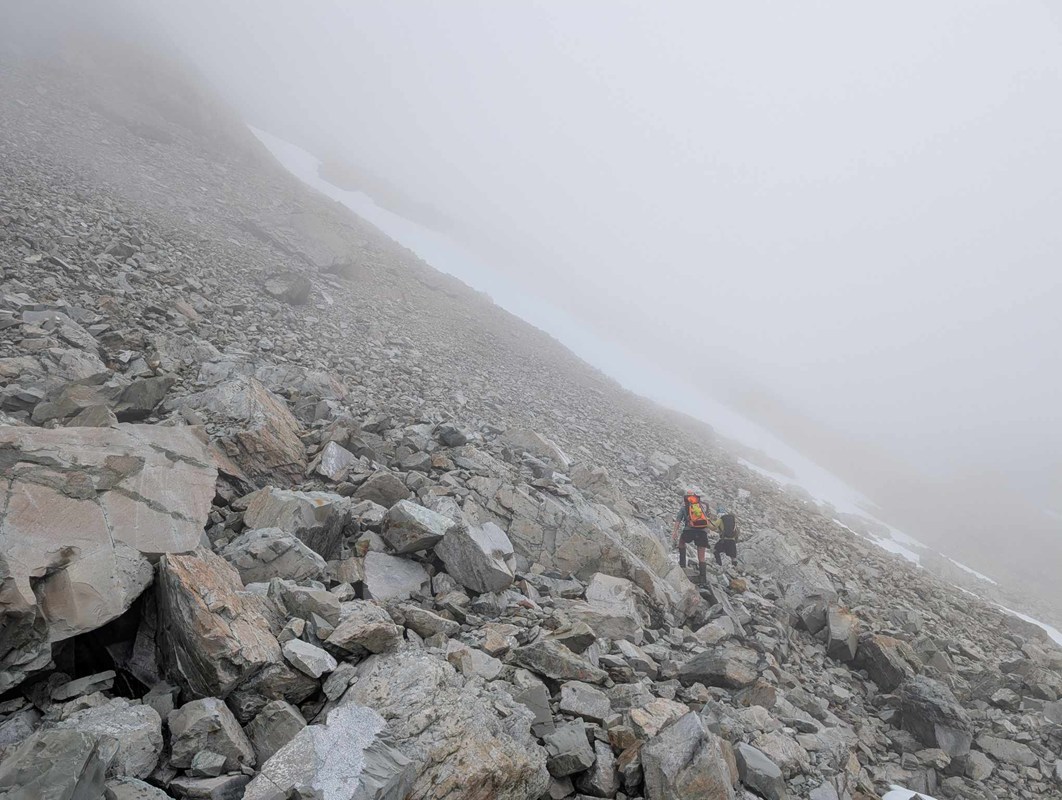
From here the tramp actually got serious. We changed out of our shoes and into our heavy boots, and stashed a bunch of food for the trip home. It took a while to find the correct creek to get up the hill, but eventually we found the track and it was punishing! West coast hills don’t mess around, it’s straight up for about 1km to the bushline. Cloud was drifting in and out and occasionally we would catch glimpses of the mountains above and around, or the valley far below. From Blue Lookout, occasional cairns marked the route towards False Blue but it was frustratingly slow travel. The route weaved between and over boulders, and up and down ridges and gullies, and while it was mostly tussock tops there were still bushes to get snagged in. Below the hill plunged into a deep gorge, and across the valley were some impossible steep canyons and waterfalls coming down from the Lambert Glacier, which we couldn’t quite see. Past False Blue Lookout there were less boulders, but more gullies that we were constantly weaving our way in and out of. Eventually we got to 1392 and our first glimpse up the head of the Lord Valley. It looked dramatic and hostile, towering cliffs of crumbling rock(choss) flanked either side. We decided it was 4pm and high time for lunch, then we were enjoying lunch so much we decided to set up camp since there was a nice spot nearby. Since we were a fast group and there was plenty of daylight we could take it easy. Evening entertainment was provided by anchoring the fly with climbing cams, and practicing our crevasse rescues.
Next day the weather was beautiful, and we dithered until after 10am getting packed up. Sidling down into the valley was much of the same as yesterday, in and out and in and out and in and out… ect. From the bottom of the valley it was an easy boulder hop up to the top of the valley… and… confusion. 2 groups had been here in about 2010 and both had described it as an easy walk up the end of the valley to Strauchan Pass. But what greeted us was steep rock slabs covered in loose gravel. The glacier must have previously provided easy access, but now it had melted and left behind a difficult rock climb, too difficult to be worth attempting in such a remote location. Shaken but not defeated, we turned to plan B. The previous day, between the vertical cliffs of loose choss, Hamish had spotted a thin ledge of snow that could provide a passable traverse out of the valley. We weren’t sure of the details, but it was worth a shot, right? At about the soonest point down the valley, we located a promising route up. The lower part of the valley was made of moraine, which is a loose mixture of sharp rocks held together. It’s the byproduct of the churning of glaciers, left behind when the glaciers melt. I setoff first, kicking steps and trying not to kick rocks on the rest of the team. The spur narrowed and steepened, until eventually I was balanced on a pile of loose rocks with steep drops either side and no clear way to continue. I felt that “Oh Fuck” feeling in my gut, and realized that even if I make it past this, there’s no way the rest of the team is going to make it. So a fun but careful gravel slide back down to Hamish, and we are debating with each other and the rest of the group to try the nearby gully full of avalanche debris. Then we hear a “thud”, “clonk”, and a fridge sized boulder rains down from far up on the cliffs above. That basically settles that, and we run away as fast as we can from this horrible place. We’re trapped in the Lord’s castle of choss with no way out except for sadly retreating the way we came.
Camp was across the river, which means that first we had to do my favorite part of West Coast tramping, boulder hopping across the rivers. The joy of leaping between giant boulders, raging torrents beneath you, on the dry, grippy, flood washed rock surface, is one of life's great joys. Sometimes it’s the only way across the river, or the only way up and down the river. Anyway, we found some nice dry patches of moss, and even managed to get a scrub fire going. Weather held out with only occasional drizzle. Next morning, Ivan remembered that he’d heard from a friend of a friend(or something) that there was a nice route onto the Heim Plateau from here, so why don’t we go check that out. So we did, at our classic 10am departure, boulder leaping across the brilliantly named “Swift Water”, and weaving our way up the south side of the valley through the scrub, and eventually across rocks and snow, through the clouds, round .1918 and .2013, and up a nice snow slope to the main divide. We caught glimpses through the clouds and over the edge down to the Heim Plateau, a great flat mass of white, certainly living up to it’s name. It was scarred with gaping crevasses. From here we roped up, all 5 of us on Hamish’s fancy 7.5mm half rope. This was the part I was most excited about, I knew about glacier travel but I’d never done it before. The way down was very steep and soft, we were plugging big steps down the hill, constantly trying to manage the rope slack between all of us. I was near the back so I’ve got no idea what was going on at the front, but eventually Ivan called up that there was a big shrund(Bergshrund!, pronounced in a loud and comical German accent, meaning a large crevasse on the edge of a glacier), that was going to take too long to get passed and it was 4pm so we should probably plug our way back up. Typically mountaineers go up in the morning and down in the evening, so many jokes were exchanged about doing things in reverse. From the top of the hill we had a wonderful glissade down the snow slopes. Glissading is like skiing, but in tramping boots, it requires much better balance and I think it’s far more fun. Unlike skiing, the best conditions are afternoon summer slush. We found our way back to camp without getting lost.
At this point I was well and truly coming down sick. I drank about 10 litres of water that day and was coughing, nose was running, ect, so it was time to go. Tramping when you're sick takes a lot more effort, the air doesn’t go in and out nearly as easily. We struggled back in and out of the gullies, but it was made easier since I had developed a strategy, which is to stay at the same height wherever possible. I will attach a mathematical proof of why this is a good strategy. Unfortunately I was feeling too sick even to enjoy a swim at False Blue Lookout. Finally back at Hunters Hut, we met a WTMC group who had come out of the Lord too, having come down from the Gardens. Next morning, a pair of lads came past heading up that way as well, to hunt the unbelievable Tahr population. At times it looked like the whole hillside was moving with herds of 50 of them, you could sit on the other side of the valley with a good scope and pick off the whole lot 1 by one.
Ivan and I had a good yarn about philosophy on the way out down the Whanganui, and we headed off our separate ways for the next adventure. My “man flu” probably came from Tadgh, and was passed on to Hamish and Ivan who came down with it on the next trip. I ended up in Arthurs Pass where I attempte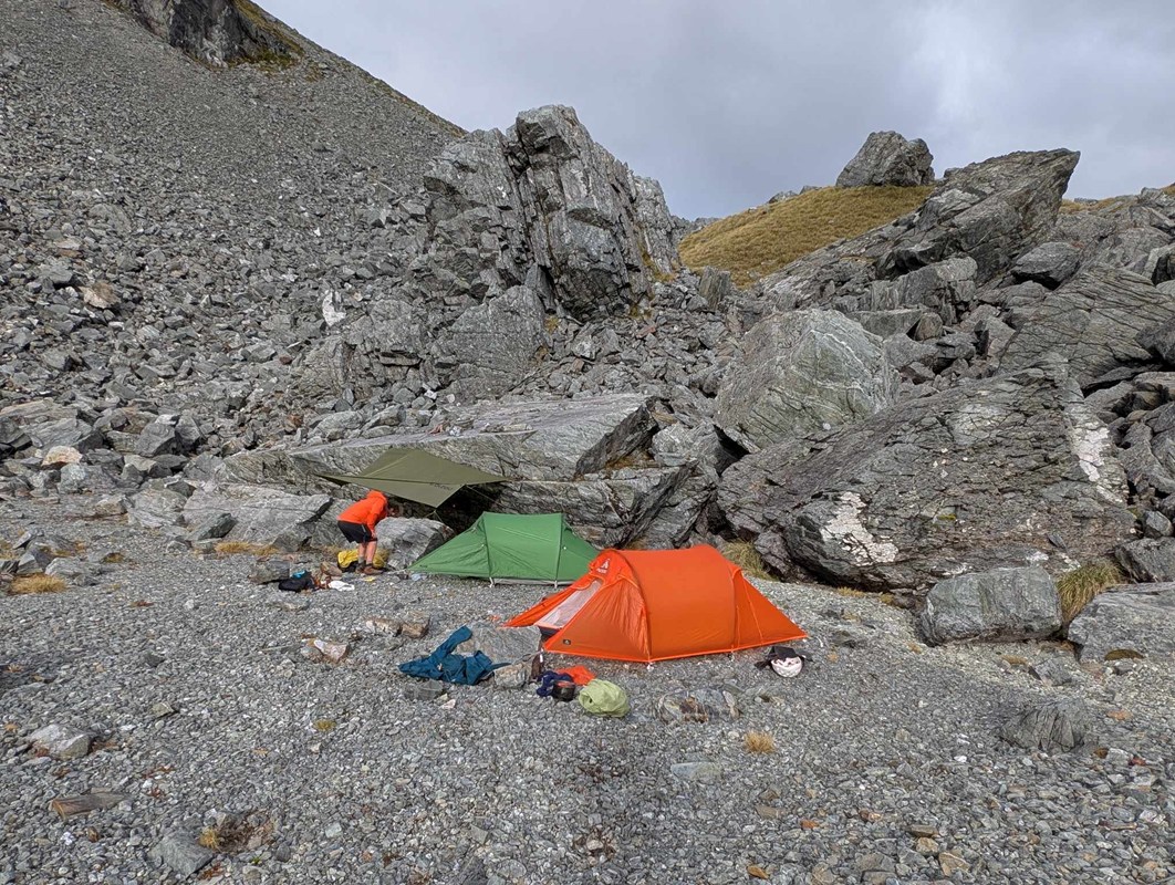 d(and failed) to climb Mt Rolleston twice, but that’s another story.